
Purpose of this article is to provide basic primer for someone wishing to understand relative tactics, techniques, and procedures (TTP) for observing a specific facility and understanding what is happening at that facility, reporting on that activity, and being knowledgeable about the changes.
Some definititions:
Facility: A facility is a specific place located on the Earth where structures features or objects are located which have particular Nexus to the event or action supported or planned.
Reconnaissance : is the active exploring or observing an area or situation to gather information, often to understand a facility, position, resources, or intentions, or to assess terrain, thereby gaining a strategic advantage before taking further action.
Surveillance: is passive systematic observation and monitoring of a person, population, or location, with the purpose of information-gathering.
Normalcy: is the state of being usual, expected, or ordinary, a return to how things normally function.
Normalcy Statement: is a general description of a facility, its components, functions and activities based on R&S derived information allowing for identification of significant increases or decreases in activity levels.
Periodicty: is the characteristic of happening regularly.
Reconnaisaissance and Surveillance Plan: A reconnaissance and surveillance (R&S) plan is a strategy for gathering timely information about an area, opposing force, or situation, using reconnaissance (active, focused searches for specific answers) and surveillance (passive, continuous watching) to build situational awareness. It details what, where, and how assets will collect information (e.g., drones, observors) to support the overall mission, ensuring affinity groups know what's happening on the ground.
Situational awareness: is simply knowing what's happening around you, but it also involves understanding the meaning of those events and predicting what might happen next to make better decisions and react safely. It's about perceiving your environment, comprehending its significance, and projecting future states, moving from just seeing to understanding and anticipating.
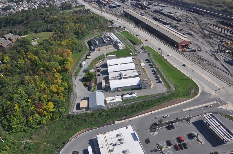
CASE STUDY: Former Altoona PA, ICE Armory located at 320 E Chestnut Ave, Altoona, PA 16601 Lat Long vic: 40.5285333669383, -78.3906370294451


Historical background: ICE Armory Operations began in 2017 at the site, which handled “the acquisition, testing, issuance and maintenance of all ICE-owned firearms, law enforcement equipment and ammunition,” according to a 2017 news release from the agency.
The site was also used for storage of seized weapons, McGuire said.
The facility had been linked to immigration since July 1994, when ICE predecessor Immigration and Naturalization Service turned it into a weapons repair facility, according to information from Mirror archives.
From 1947 until shortly before INS took it over, the property was the site of a U.S. Naval Reserve Training Center, according to information provided by local historian Michael Farrow, who researched archives of the Altoona Tribune; and the Mirror archives.
Long before, the property became the site of the Altoona Astronomic Station, according to a pamphlet written by Farrow.
In 1890, at the request of the Pennsylvania Railroad, the U.S. Coast and Geodetic Survey established a coordinate marker on the property, consisting of a copper bolt with an incised cross set in the crotch of an upright U-shaped block of sandstone, according to a pamphlet by Farrow. On the pier was carved “Lat 40 degrees 31′ 45″ 48′” ; Long 78 degrees 23′ 12: 79′” Altitude 1,288.1 FT,” according to Farrow. It required six days of signals to establish the longitude and six nights of star observations to establish the latitude.
NORMALCY STATEMENT: Site of the main armory remains idle. Some derelict, impounded cars sit on the west side of the property facing the Martin's grocery store. Imagery from 22 Jan shows the current count and type. Most have license plates removed. Rest of the site remains unoccupied and recent snowfall has not been plowed. An increase in activity was noted on 21 Jan (not imaged) to include 1 Logan Township police Ford Interceptor as well as 1 U/I unmarked Gray in Color Ford Interceptor clearly indicative of a police/security organ type vehicle. Google Maps now indicates the eastern building complex is listed at the "City of Altoona - Training Center" date of update unknown.
Reconnaissance Photos from 22 JAn 2025 posted below taken between 1400 and 1500 local time.
Impounded/derelict? cars East side:


Main Entrance Unplowed:


R&S Plan: The facility is currently back in the ownership of the City of Altoona. The probablity is high that a combined used of the facility by Blair County law enforcement is likely, especially the ranges and secure storage areas. Best understanding and analysis will be gained by frequent daytime directed reconnaissance, solicitation of public information though PA Right to Know (RTK) laws and press releases, general surveillance of the site by local workers and unhoused/mortage free persons from the area.
Excellent observation from Martins gas pumps of Western Side. Public observation of South and Main Entrance from Chestnut Ave Sidewalk. Poor access from North and NE on highground due to priavte property and extensive vegetation (especialy summertime)
Reccomended Cover Plan Stories for Observers: "Trainspotting" of the nearby Nortfolk Southern/PRR railroad yard - ALWAYS take picture of the trains.
Indicators of Non Local Law Enforcement Use:
1. Presence of large numbers of unmarked vehicle with non MG (Municipal Government) plates
2. Maintenance of parking areas during and after high impact weather events
3. Provision of additional radio/satellite communications antennae equipment
4. Activation of perimeter lights - especially at main gate.
.jpg)
No comments:
Post a Comment